Boundary Analysis in Topographic Surveys
Boundary analysis is crucial for defining property lines, avoiding disputes, and ensuring smooth construction or real estate transactions. Here's what you need to know:
Purpose: Maps property boundaries, identifies easements, and prevents encroachments.
Cost: Typically $2,400–$5,000+, depending on property size and complexity.
Key Challenges:
Errors in old records.
Weather and site access issues.
Mismatched legal descriptions and site conditions.
Solutions:
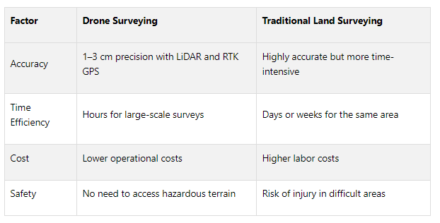
Use modern tools like LiDAR, RTK GPS, and drones for precise measurements.
Cross-check data with historical records and official maps.
Establish accurate reference points with GNSS technology.
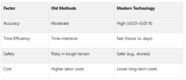
Old vs. New Methods: Modern tools are faster, safer, and more accurate compared to traditional surveying techniques.
Quick Comparison:
Takeaway: Combining licensed surveyors’ expertise with advanced tools ensures precise, legal property boundaries, saving time and avoiding costly disputes.
How to Conduct Accurate Property Boundary Surveys | Dudek Mapping and Surveying
Common Problems in Boundary Analysis
After exploring the advantages of boundary analysis, it's important to address the challenges that often arise during the process. These obstacles can disrupt commercial real estate projects and lead to costly legal disputes. By identifying and understanding these issues, developers, investors, and surveyors can better prepare for potential complications.
Errors in Old Records
One of the biggest hurdles in boundary analysis comes from inaccuracies in historical records. Many legal descriptions - some written decades or even centuries ago - are riddled with errors due to outdated surveying practices and unclear documentation standards. Back then, surveyors often relied on natural markers like trees or streams, which have since shifted or disappeared over time.
The financial fallout from these errors can be severe. For instance, a 2020 boundary dispute in Georgia escalated into a lengthy court case because of conflicting property deeds. Similarly, a New York homeowner in 2019 faced a lawsuit over a boundary discrepancy caused by a mistake in a decades-old deed. These examples highlight how inaccuracies in old records can lead to significant legal and financial headaches.
Such problems often arise from misinterpreting documents or depending on flawed data from earlier surveys. Errors in property deeds, surveys, or other legal documents can cloud title clarity and ignite disputes between neighbors.
But record inaccuracies aren't the only challenge - physical site conditions can also complicate boundary analysis.
Site Access and Weather Issues
Weather and site conditions frequently disrupt surveys and compromise accuracy. Prolonged rain, snow cover, extreme heat, or storms can make sites inaccessible and delay measurements. On top of that, dense forests, steep terrains, or marshy areas can further hinder access and leave surveyors with incomplete data.
“Being prepared, flexible, and maintaining open communication with clients are key elements in successfully navigating weather-related obstacles in boundary surveying.”
Surveyors often have to adapt to these challenges, which may require multiple site visits or the use of specialized equipment to gather accurate data. These delays can stretch project timelines and inflate costs, adding yet another layer of complexity to boundary analysis.
These physical challenges often intersect with legal ambiguities, which lead to even more complications.
Legal Descriptions Don't Match Site Conditions
Another common issue emerges when the legal descriptions in property deeds fail to align with the actual conditions on the ground. These discrepancies can stem from historical errors, natural landscape changes, or mistakes in past surveys.
This problem is particularly troublesome in commercial real estate, where precise boundaries are crucial for development plans and regulatory compliance. When deed descriptions conflict with on-site realities, surveyors must dig deep into historical records, consult neighboring property owners, and sometimes provide expert testimony to resolve the discrepancies.
Boundary errors like these can have far-reaching consequences, such as affecting zoning rules, setback requirements, or environmental buffer zones. Resolving these conflicts often requires detailed land surveys, which can serve as vital legal evidence in disputes. Professional surveyors also play a critical role in court cases, offering the technical expertise needed to untangle complex boundary issues.
How to Fix Boundary Analysis Problems
Once you've identified common issues in boundary analysis, modern methods can provide practical solutions. By using advanced tools, cross-checking various data sources, and setting up accurate reference points, surveyors can greatly enhance precision and resolve even the most challenging boundary disputes.
Using Modern Survey Equipment
The surveying world has seen a major shift thanks to technology. Tools like drones equipped with LiDAR and RTK GPS have made it possible to achieve precision within 1–3 cm, which is incredibly useful for detailed boundary work. For instance, the DJI Matrice 350 RTK is a professional-grade option with extensive capabilities, while models like the SkyFront Perimeter 8 excel in covering large areas.
When choosing between photogrammetry and LiDAR, it’s all about the project’s needs. Photogrammetry is great for horizontal accuracy, hitting as close as 1 cm, but its vertical accuracy is usually around 2–4 cm. LiDAR, on the other hand, delivers both horizontal and vertical accuracy within 1–3 cm, making it especially effective in areas with dense vegetation or uneven terrain.
GNSS receivers with tilt compensation have also addressed long-standing challenges in boundary surveying. For example, the Reach RS3 RTK offers horizontal accuracy of 7 mm + 1 ppm and vertical accuracy of 14 mm + 1 ppm.
“The Reach RS3 is a game changer for my team. The tilt compensation allows accurate surveying of hard-to-reach points, and building corners and walls can now be shot directly without using offsets. I am amazed at the accuracy, even with fairly large tilts!”
Cloud-based data management has further streamlined the process, centralizing survey data and allowing for scalable storage solutions.
With advanced tools in place, the next step is to validate these measurements using multiple data sources.
Checking Data Against Multiple Sources
Resolving discrepancies in historical records and legal descriptions requires thorough cross-referencing. This means comparing field data with official documents, government databases, and neighboring property information to form a complete and accurate picture.
Start by gathering key land documents like cadastral maps, survey records, and title deeds, which are often available through government offices or online portals. Many areas now provide GIS-based platforms that overlay geospatial layouts with official boundary data, making it easier to verify boundaries.
Land mapping software also plays a crucial role, enabling direct comparisons between physical surveys and digital maps. These tools integrate satellite imagery, drone data, and GPS measurements to highlight inconsistencies. Additionally, GIS-based systems centralize data on boundaries, ownership, and zoning, simplifying the process of spotting errors.
Combining GPS technology with traditional methods allows surveyors to cross-check and verify measurements effectively. It's also important to ensure that field data aligns with the property's historical development, as this can reveal conflicts between older survey methods and current site conditions.
Setting Up Accurate Reference Points
Establishing reliable reference points is vital for precise boundary analysis. When setting up a GNSS base station, pay close attention to the coordinate system and positioning accuracy. Remember, the accuracy of the rover depends entirely on the base's placement, so even small shifts can impact all measurements.
Choose the correct coordinate system and configure your software with the appropriate horizontal datum, projection, and vertical datum settings. Whenever possible, use verified coordinates for your base. This can be achieved by manually entering data from established survey monuments or using the Average FIX method with an NTRIP service for real-time corrections. If you're working in an area where the known point is obstructed, the base shift method can help by applying a linear adjustment based on a nearby accessible point.
For remote locations without known points or internet access, static processing is a reliable alternative. This involves logging raw data at the base station, downloading CORS logs, and post-processing them with specialized software.
RTK technology offers real-time corrections with minimal delay, providing better precision compared to traditional DGPS methods. However, multipath interference can still be an issue in complex environments. To minimize this, carefully select the site for your base station, maintain good satellite reception, and ensure stable positioning during data recording.
Transform Your Real Estate Strategy
Access expert financial analysis, custom models, and tailored insights to drive your commercial real estate success. Simplify decision-making with our flexible, scalable solutions.
Old vs New Survey Methods
Accurate boundary analysis plays a vital role in commercial real estate, and the tools and techniques used for surveying have come a long way. While traditional methods laid the groundwork, advancements in technology have transformed the way surveys are conducted, making them faster, more precise, and cost-effective. Recognizing these differences helps professionals in the field make better decisions about survey needs and budgets. Let’s dive into how these methods compare.
Pros and Cons of Old Methods
Older surveying techniques relied on tools like theodolites, tape measures, and manual leveling equipment. When handled by experienced surveyors, these tools could deliver reliable measurements. However, the process was slow and required significant manpower.
Traditional methods also had their drawbacks. For starters, bad weather could easily delay work, and surveying in rough terrain often posed safety hazards. Costs were another concern - surveyors charged between $220 and $450 per hour on average, with additional fees of $85 to $160 per hour for researching property records. On top of this, mastering these techniques took years of hands-on training, making skilled surveyors hard to come by.
These challenges paved the way for the adoption of modern technologies that address many of the inefficiencies and risks associated with traditional surveying.
Why New Technology Works Better
Modern surveying tools have revolutionized the field, tackling many of the issues that plagued older methods while delivering even greater accuracy. For example, GPS technology has drastically reduced the time and effort required for fieldwork, achieving levels of precision that were previously unimaginable.
LiDAR technology has taken things a step further by creating detailed 3D maps. It can even "see" through vegetation to capture ground contours. Airborne LiDAR systems, for instance, can achieve vertical accuracy within 4 inches (10 centimeters), making it possible to map large areas quickly and with incredible detail.
“GPS technology, with its satellite-based positioning, has drastically reduced the time and labor required for field surveys, achieving accuracies that were unthinkable with traditional methods.”
Drones have also become a game-changer. They can cut field data collection time by as much as 90% compared to traditional methods. For topographic surveys, drones deliver accuracy levels of about 0.8 inches (2 cm), which is more than sufficient for most boundary analysis needs.
Meanwhile, total stations combine the best of both worlds by offering precise electronic measurements while reducing human error during calculations. These modern tools also enhance safety - drones, for example, can survey hazardous areas like steep cliffs or unstable ground without putting personnel at risk.
Side-by-Side Comparison: Old vs New Methods
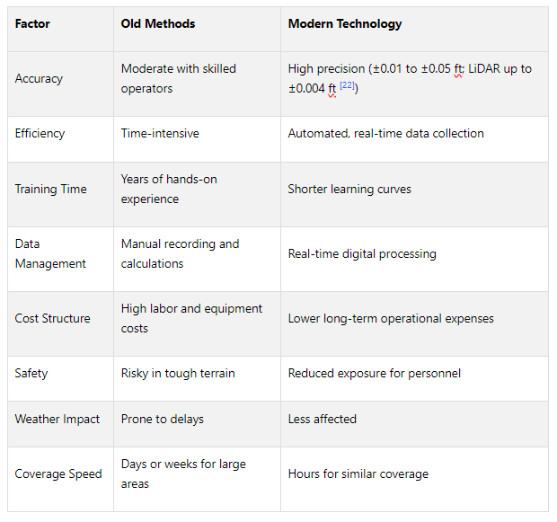
Modern survey tools consistently outperform traditional methods in both accuracy and efficiency. For instance, topographic surveys today can achieve precision levels of ±0.01 to ±0.05 feet (3 to 15 mm), while LiDAR surveys can be as precise as ±0.004 feet (1.2 mm). These advancements don’t just save time - they also cut costs and improve safety, all while delivering higher-quality data. From basic 2D maps to intricate 3D models, modern tools meet the demands of even the most complex projects. It’s no surprise that the global market for GPS and LiDAR systems is expected to hit $4.7 billion by 2025, reflecting the growing reliance on these technologies.
Working with Experts and Technology Platforms
Getting boundary analysis right is a must in commercial real estate. It’s not just about marking lines on a map - it’s about avoiding disputes, preventing delays, and steering clear of legal headaches. This requires a blend of expert surveying and smart technology.
Hiring Licensed Surveyors
When it comes to determining property boundaries, licensed surveyors are the go-to professionals. Their training spans law, math, engineering, and physics, equipping them with the skills needed to provide precise and legally sound property line determinations. This precision is essential to sidestep conflicts with neighboring property owners that could derail commercial projects.
But surveyors do more than just mark boundaries. They identify and document existing easements - like rights of way, drainage, or utility access - that could impact a property. They also ensure compliance with local zoning laws and land use regulations. McSteen Land Surveyors emphasizes the importance of their role:
“Land surveying is crucial to responsible land development and a professional land surveyor plays an integral role, from mapping project areas, identifying potential risks, and verifying plans. After all, it is essential for every project to start with good information, as that is the basis for everything that goes forward with that development or construction.”
Surveyors also assist with land planning and development by providing detailed information on topography, elevation, and other land features. This data helps prevent disputes and can even enhance property value. With surveyors earning a median annual wage of $72,740 as of May 2024 and the profession expected to grow by 6% between 2023 and 2033, their role is becoming even more critical as technology advances.
Pairing the expertise of surveyors with cutting-edge technology platforms takes boundary analysis to a whole new level.
Using Technology Platforms for Complete Solutions
Modern technology platforms are transforming how boundary analysis is conducted. These systems integrate seamlessly with real estate workflows, making decision-making faster and more efficient. Take BlackRock, for example. They implemented an automated platform that pulls data from over 200 sources, analyzing traditional metrics alongside alternative data like mobile phone movement, social media trends, and satellite imagery. This approach cut analysis time by 65% and allowed them to spot opportunities weeks ahead of competitors.
Such platforms don’t just save time - they deliver measurable results. Research shows that integrated platforms can increase deal close rates by 59%, reduce customer churn by 58%, and speed up decision-making by as much as 30%. Additionally, automated data collection slashes research and analysis time by up to 70%, according to Deloitte, while KPMG found that operational costs could drop by 15–25%.
Platforms like The Fractional Analyst take this further by combining survey data with financial analysis and expert insights. They provide services like underwriting, market research, asset management support, and even investor reporting. This all-in-one approach helps real estate professionals streamline their processes, from boundary analysis to deal closure.
“The most successful automated systems are those that make complex analysis simple for decision-makers, rather than exposing all the underlying complexity.”
While these platforms offer incredible benefits, choosing the right service model is just as important.
Full-Service and Self-Service Options
Whether to go full-service or self-service depends on factors like expertise, compliance needs, and project complexity. Full-service options are ideal for intricate projects, offering expert guidance and robust data integration. On the other hand, self-service platforms like CoreCast are better suited for routine tasks, provided there’s proper governance in place.
Full-service solutions handle everything - from technical surveying to data integration and compliance documentation. For example, platforms like The Fractional Analyst ensure that every aspect of boundary analysis aligns with legal and industry standards.
In many cases, a hybrid approach works best. Full-service support can be used for complex legal and technical needs, while self-service tools handle routine data analysis. This combination maximizes accuracy and efficiency while keeping costs in check.
“The future belongs to real estate organizations that can not only collect and analyze data automatically but can embed those capabilities into every aspect of their decision-making processes.”
Conclusion
Main Points
Accurate boundary analysis plays a key role in the success of commercial real estate projects. It helps avoid legal battles, prevents construction delays, and eliminates the need for expensive redesigns. In short, precise mapping sets the stage for smooth project execution and legal confidence.
The cost of boundary surveys varies widely. For smaller properties, it typically ranges from $100 to $600. On the other hand, complex commercial projects can exceed $2,000. Surveyors generally charge between $220 and $450 per hour, while record research fees fall between $85 and $160 per hour. While these costs may seem high, they pale in comparison to the potential losses from disputes or construction errors.
Modern tools like RTK GPS and LiDAR-equipped drones are game-changers. They deliver centimeter-level precision and can complete surveys in days rather than weeks. These advancements bring clear benefits in terms of accuracy, speed, and cost-efficiency.
“A boundary survey is a vital tool for any property owner or developer. It establishes clear property limits, prevents disputes, and ensures projects move forward smoothly and legally.”
Even with cutting-edge technology, the role of licensed surveyors remains indispensable. They ensure all technical measurements meet legal standards, identify easements, and provide the detailed documentation needed for financing and title insurance. Combining expert oversight with advanced tools strengthens decision-making in real estate projects.
To ensure success, always conduct a boundary survey before starting any construction or development. Verify that the surveyor is licensed and knowledgeable about local regulations. It’s also wise to re-survey properties every 5 to 7 years to maintain accuracy. By blending advanced technology with professional expertise, property developers can build a strong foundation for their projects.
FAQs
-
Modern tools like LiDAR and drones have revolutionized boundary analysis in topographic surveys, offering precision and efficiency that older methods simply can't match. These technologies provide detailed, high-resolution data much faster than traditional techniques, making them especially valuable for mapping boundaries in hard-to-reach or densely vegetated areas.
Beyond speed and accuracy, they also cut costs and improve safety. By collecting data remotely, surveyors can avoid navigating dangerous terrain, reducing risks significantly. Plus, their ability to consistently capture data makes them perfect for tracking changes over time, delivering reliable and repeatable results every step of the way.
-
To resolve differences between legal descriptions and actual site conditions, surveyors begin by thoroughly examining all relevant legal documents, including deeds and plats. This step ensures they have a solid understanding of the property's boundaries as defined on paper.
Using detailed boundary retracement techniques and following state-specific regulations, surveyors work to establish accurate boundaries. Tools like the ratio of closure and relative error analysis play a key role in confirming precision and meeting professional standards. Importantly, they avoid tampering with original survey markers unless they have legal authorization, as doing so could spark disputes. Expertise and proper training are essential to minimize mistakes and deliver dependable results.
-
Property developers can cut down on risks tied to errors in historical boundary records by arranging routine boundary surveys and keeping them updated with the most current information. Hiring professional surveyors to confirm property lines and records is a key step to avoid potential inaccuracies.
Additionally, developers should think about creating formal boundary agreements with neighboring property owners. Reviewing title histories in detail and addressing any boundary concerns early in the planning phase can also make a big difference. Clear communication with all involved parties and proactive checks of property documents can prevent disputes and keep projects on track.
Focusing on precise and up-to-date surveys helps developers protect their projects from expensive boundary-related issues.